Visual Materials
Map of Jamaica ; Barbados

You might also be interested in
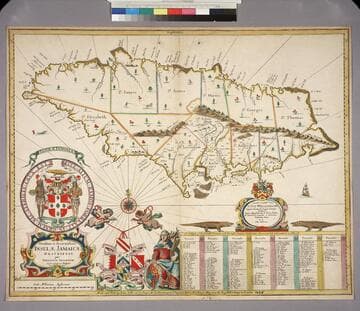
Novissima et Accuratissima Insulae Jamaicae Descriptio per Johannem Sellerum. Hydrographum Regium Londini
Visual Materials
A catalogue of settlers and their locations. Kashnor dates as [1675]. See 105:463M for another copy. Cartouche: Coat of Arms, figures, dedication cartouche. Table: A Catalogue of the Severall Precincts, with the most Eminent Settlements therin, marked and numbered as followeth. Relief: pictorial. Graphic Scale: Miles. Projection: Cylindrical. Watermark: Device possible lettering. Printing Process: Copper engraving. Other Features: Cartouche. Verso Text: MS notes: 802 29.
093:802 M
Image not available
New Map of South America, Shewing it's General Divisions, Chief Cities & Towns Rivers, Mountains &c. Dedicated to His Highness William Duke of Gloucester
Visual Materials
Kashnor attributes this map to Wells and dates as [1698]. RLIN record suggests 1700. Cartouche: Elaborate with Royal coat of arms, by a different artist than the map maker.. Prime meridian: Ferro. Relief: pictorial. Graphic Scale: Miles. Projection: Pseudocylindrical. Printing Process: Copper engraving. Other Features: Cartouche. Verso Text: MS notes: 40 615.
093:615 M
Image not available
Carte de l'Amerique Septentrionale 1754
Visual Materials
Kashnor notes, "Shows the coast of California and the North-West to the supposed Strait of Anain. Kashnor states publication as Paris, dates as [1755] and attributes to [Jean Palariest]. See 105:217M for variant map. RLIN record identifies maker as Palairet, publication place as London, date as 1755. MS notes: By Jean Palariat 1755. 13. (upper right). Prime meridian: Ferro. Relief: pictorial. Graphic Scale: Miles (naut.), leagues. Projection: Pseudocylindrical. Watermark: Crowned fluer-di-lis IV. Printing Process: Copper engraving. Other Features: Cartouche. Verso Text: MS notes: 167 13.
093:167 M
Image not available
Plan of the Town and Fortifications of Montreal or Ville Marie in Canada
Visual Materials
Kashnor notes, "Locates Governor Vandreuil"s Palace and Longueil's House, with the old religious buildings." Publication date and place from below neatline. This is a larger engraving of the same material covered by 093:300 and the RLIN record. Detailed city plan.. Relief: hachures. Graphic Scale: Toises, Yards. Projection: Plane. Watermark: Crowned shield over LVC IV. Printing Process: Copper engraving. Other Features: Cartouche. Verso Text: MS note: 299.
093:299 S
Image not available
Nova Belgica et Anglia Nova
Visual Materials
Kashnor notes, "Locates Nieuw Netherland Territory, with Nieu Amsterdam on Manhattan, and Hellegat, also Nieu Plimouth and Briston in Nieu England." McCorkle gives 1635 date, suggest that Lake Iricoisiensis is confusion between Lake Champlain and Lake Winnepessaukee. Based on language and signature on verso, Van der Krogt dates this edition to between 1640 and 1643. Cartouche: Indians and Belgian shield; numerous figures and animals. Indian village. Prime meridian: Ferro. Relief: pictorial. Graphic Scale: Miles. Projection: Mercator. Printing Process: Copper engraving. References: McCorkle 635.1. Verso Text: Printed in French: La Nouvelle Belgique, & la Nouvelle Angleterre 3; C. MS note: 493.
093:493 M
Image not available
Map of the most Inhabited part of Virginia, containing the whole Province of Maryland, with Part of Pensilvania, New Jersey and North Carolina, Drawn by Joshua Fry and Peter Jefferson in 1775
Visual Materials
Kashnor dates printing as [1776]. Cartouche: Traders shipping tobacco. Table: Road distances from Williamburg and other Virginia points as recorded by J. Dalrymple in 1755.. Prime meridian: Philadelphia, Curratuck Inlet. Relief: pictorial. Graphic Scale: Miles. Projection: Cylindrical. Watermark: Crowned fleur-di-lis over GR. Printing Process: Copper engraving. Other Features: Cartouche. Verso Text: MS notes: 589 25 26.
093:589 M